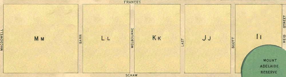
Map 2 - Sections Ii, Jj, Kk, Ll, Mm
The information in these reports provides a timeline of occurrences for each property up to 1919, including details such as conveyances and occupancy. Compiled from records at the Tasmanian Archives, the Land Titles Office, Hobart Town Gazette Valuation Rolls, and newspaper articles, this is a work in progress and will be continually updated.
All sections below have been modified from the Tasmanian Archives: Map - Bothwell (B38), AF819/1/27
View original map on the Tasmanian Archives website https://libraries.tas.gov.au/Digital/AF819-1-27
The Bothwell History pages are undergoing a major review and redesign. Information is being reorganised, new research is being added, and some pages may appear in different formats during this process.
[Ii-Ll] Frances Street - 27 acres 26 perches
Land Grant: 7 Nov 1854, [Ii], Maria (Risley) Lord, in consideration of £33.
Land Grant: 7 Nov 1854, [Jj] Maria (Risley) Lord, in consideration of £45 14s.
Land Grant: 7 Nov 1854, [Kk] Maria (Risley) Lord, in consideration of £45 14s.
Land Grant: 7 Nov 1854, [Ll] Maria (Risley) Lord, in consideration of £47.
Land Grant: 4 Dec 1854, [Ll] Maria (Risley) Lord, enrolled upon payment of £47.
Land Grant: 27 Sep 1855, [Ii], Maria (Risley) Lord, enrolled upon payment of £33.
Land Grant: 27 Sep 1855, [Jj] Maria (Risley) Lord, enrolled upon payment of £45 14s.
Land Grant: 27 Sep 1855, [Kk] Maria (Risley) Lord, enrolled upon payment of £45 14s.
Land: 18 May 1858, John McWaide (occupier), 18 acres, annual rateable value £50; includes [1], [32.2]. By process of elimination, the remaining 11 acres are [Ii].
Land: 18 May 1858, Mrs Maria Lord (owner), 50 acres, annual rateable value £80; includes [32.1].
Land: 19 Nov 1861, Executors of Edward Lord (owners), 50 acres, annual rateable value £70; includes [32.1].
Land: 15 Nov 1864, William Maskell (occupier), executors of Edward Lord (owners), paddocks, 45 acres, annual rateable value £10.
Land: 26 Feb 1867, John Henric Easton (occupier), executors of Edward Lord (owners), house, 19½ acres, annual rateable value £40; includes [1], [32.2], [33]. By process of elimination, the remaining 11 acres are [Ii].
Land: 26 Feb 1867, William Maskell (occupier), executors of Edward Lord (owners), paddocks, 45 acres, annual rateable value £10.
Land: 20 Feb 1872, William Maskell (occupier), executors of Edward Lord (owners), paddock, annual rateable value £5.
Land: 20 Feb 1872, Executors of Edward Lord (owners), paddocks, 30 acres, annual rateable value £5.
Land: 19 Mar 1878, Nathaniel Paul Allison (occupier), executors of Edward Lord (owners), land, annual rateable value £5.
Land: 19 Mar 1878, Nathaniel Paul Allison (occupier), Edward Robert Lord (owner), 35 acres, annual rateable value £20; includes [32.1].
Conveyed: 29 Oct 1891, Edward Iveagh Lord to James Williams for £350; includes [32.1].
Land: 19 Feb 1895, James Williams (owner), 64 acres, annual rateable value £20; includes [32.1].
Land: 28 Mar 1899, Arthur Charles Hirst (occupier), James Williams (owner), house, 64 acres, capital value £600, annual rateable value £30; includes [32.1].
Land: 3 Nov 1914, Arthur Charles Hirst (occupier), James Williams (owner), 58 acres, annual rateable value £6.
[Mm] Adelaide Street- 24 acres 2 roods 24 perches
Conveyed: 10 Aug 1854, Richard Allen purchased Crown Land for £74.
Land Grant: 7 Nov 1854, Richard Allen, in consideration of £74.
Land: 18 May 1858, Richard Allen (owner), partly cultivated, annual rateable value £10.
Land Grant: 13 Aug 1862, Richard Allen, enrolled upon payment of £74.
Land: 15 Nov 1864, Richard Allen (owner), partly cultivated, annual rateable value £10.
Land: 19 Mar 1878, Richard Allen (owner), arable land, 41 acres, annual rateable value £20 10s; includes [Bb3], [Oo1-part].
Property Transfer: 27 Nov 1882, estate of Richard Allen to his son, Arthur Augustus Allen.
Land: 28 Mar 1899, Charles Albert Nichols (occupier), Arthur Allen (owner), capital value £150, annual rateable value £7.
Conveyed: 7 Mar 1903, Arthur Augustus Allen to Charles Albert Nichols for £95.
Resources Used:
Ancestry: Australia, Electoral Rolls, 1903–1980. ↗
Libraries Tasmania: Census Returns for Various Districts, Tasmania; Copies of Wills Granting Probate; Deeds of Land Grants 1832–1935; Record of Cases Heard in Petty Sessions, Bothwell; Registers of Births; Registers of Deaths. ↗
FamilySearch: Australia, Tasmania, Government Gazette, 1833–1925. ↗
TROVE (National Library of Australia): The Britannia and Trades' Advocate; Colonial Times; The Cornwall Chronicle; The Courier; The Daily Telegraph; The Hobart Town Advertiser; The Hobart Town Courier; The Hobart Town Courier and Van Diemen's Land Gazette; The Hobarton Mercury; Hobart Town Daily Mercury; Launceston Advertiser; Launceston Examiner; MacPhail's Directory of Tasmania 1867-68; The Mercury; The Tasmanian; The Tasmanian Morning Herald; Tasmanian Weekly Dispatch; Tribune. ↗
The LIST (Land Information System Tasmania): Historic Deeds, Grants and Titles. ↗