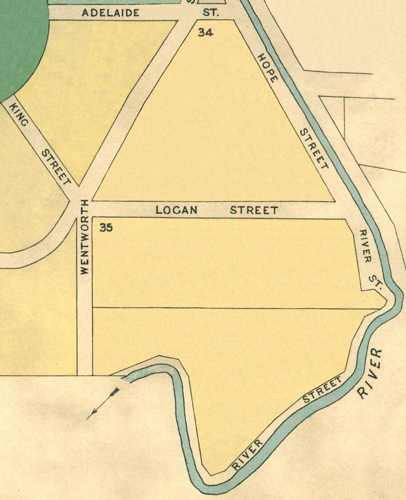
Map 2 - Sections 31 to 35
The information in these reports provides a timeline of occurrences for each property up to 1919, including details such as conveyances and occupancy. Compiled from records at the Tasmanian Archives, the Land Titles Office, Hobart Town Gazette Valuation Rolls, and newspaper articles, this is a work in progress and will be continually updated.
All sections below have been modified from the Tasmanian Archives: Map - Bothwell (B38), AF819/1/27
View original map on the Tasmanian Archives website https://libraries.tas.gov.au/Digital/AF819-1-27


The Bothwell History pages are undergoing a major review and redesign. Information is being reorganised, new research is being added, and some pages may appear in different formats during this process.
[31] Schaw Street - 10 acres
Land: 18 May 1858, William Horne (occupier), The Queen (owner), annual rateable value £5 (TGG: "Valuation Roll," 1858, p696-697, https://www.familysearch.org/ark:/61903/3:1:3QS7-L98F-VZVR)
Land: 6 Dec 1859, William Horne (occupier, erased), The Queen (owner), annual rateable value £5 (TGG: "Valuation Roll," 1859, p1556-1557, https://www.familysearch.org/ark:/61903/3:1:3QS7-L98F-JT43)
Land: 20 Nov 1860, William Moyes (occupier), The Queen (owner), annual rateable value £5 (TGG: "Valuation Roll," 1860, p1882-1883, https://www.familysearch.org/ark:/61903/3:1:3QS7-L98F-VQGX)
Land: 19 Mar 1878, John Hale (occupier), Church of Scotland (owner), annual rateable value £5 (TGG: "Valuation Roll," 1878, p494-495, https://www.familysearch.org/ark:/61903/3:1:3QS7-898F-J97X-7)
Land: 28 Mar 1899, David Wylie (occupier), Trustees Presbyterian Church (owners), capital value £100, annual rateable value £5 (TGG: "Valuation Roll," 1899, p328-329, https://www.familysearch.org/ark:/61903/3:1:3QS7-L98F-VDMC)
[32] Wentworth Street - 7 acres 18 perches
Land Grant: 20 Feb 1837, Alexander Reid (RD1: Alexander Reid, p175/1837, https://libraries.tas.gov.au/Digital/RD1-1-3/RD1-1-3P175JPG)
Advertisement: 22 Aug 1837, "To be Sold" (CT: "To Be Sold," 22 Aug 1837, https://trove.nla.gov.au/newspaper/article/8650243)
Land Grant: 17 Mar 1838, Alexander Reid, enrolled (RD1: Alexander Reid, p175/1837, https://libraries.tas.gov.au/Digital/RD1-1-3/RD1-1-3P175JPG)
Conveyed: 30 Dec 1840, [32.2], 5a, Alexander Reid to John McWaide for £50; includes [33] (LIST: Alexander Reid, historic deed, no 03/1002)
Conveyed: 24 Jan 1848, [32.1], 4a, Alexander Reid to Robert Wilson for £10 (LIST: Alexander Reid, historic deed, no 03/3293)
For more information, go to [32.1] Wentworth St & [32.2] Wentworth St
[32.1] Wentworth Street - 4 acres
Census: 1 Jan 1848, Rev Robert Wilson (owner, occupier), stone, unfinished, inhabited (CEN1: Robert Wilson, p11/1848, https://libraries.tas.gov.au/Digital/CEN1-1-74-11)
Conveyed: 24 Jan 1848, Alexander Reid to Robert Wilson for £10 (LIST: Alexander Reid, historic deed, no 03/3293)
Advertisement: 4 May 1849, "Bothwell" Clifton Priory (CT: "Bothwell," 4 May 1849, https://trove.nla.gov.au/newspaper/article/8764878)
Residence: 18 May 1858, Mrs Maria Lord (owner, occupier), house, 50 acres, annual rateable value £80; includes [Jj-Ll] (TGG: "Valuation Roll," 1858, p698-699, https://www.familysearch.org/ark:/61903/3:1:3QS7-898F-VZZ3)
Residence: 19 Nov 1861, Executors of Edward Lord (owners), house, 50 acres, annual rateable value £70; includes [Jj-Ll] (TGG: "Valuation Roll," 1861, p1694-1695, https://www.familysearch.org/ark:/61903/3:1:3QS7-898F-J93K-Z)
Residence: 8 Mar 1865, William John Pickett Bedford, landholder (RGD33: Given Name Not Recorded Bedford, no 8/1865 (https://libraries.tas.gov.au/Digital/rgd33-1-43p307j2k)
Residence: 13 Mar 1866, William John Pickett Bedford (occupier), executors of Edward Lord (owner), house, annual rateable value £30 (TGG: "Valuation Roll," 1866, p691, https://www.familysearch.org/ark:/61903/3:1:3QSQ-G98F-VH68)
Advertisement: 4 Jan 1870, "Boarding School for Young Ladies" (MERC: "Boarding School for Young Ladies," 4 Jan 1870, https://trove.nla.gov.au/newspaper/article/8873956)
Residence: 7 Feb 1871, Mrs Sarah Collet (occupier), executors of Edward Lord (owner), house, annual rateable value £20 (TGG: "Valuation Roll," 1871, p186-187, https://www.familysearch.org/ark:/61903/3:1:3QS7-L98F-KSSD)
Advertisement: 17 Jun 1871, "Preliminary Notice" Auction, household furniture & effects (MERC: "Preliminary Notice," 17 Jun 1871, https://trove.nla.gov.au/newspaper/article/8868285)
Residence: 20 Feb 1872, Hannah Paton (occupier), executors of Edward Lord (owner), house, annual rateable value £20 (TGG: "Valuation Roll," 1872, p408-409, https://www.familysearch.org/ark:/61903/3:1:3QS7-898F-J9MW-Y)
Property Transfer: 8 May 1874, Executors of Edward Lord to his son, Edward Robert Lord (LIST: Edward Robert Lord, historic deed, dealing no 06/0020)
Residence: 19 Mar 1878, Nathaniel Paul Allison (occupier), Edward Robert Lord (owner), house, 35 acres, annual rateable value £20; includes [Jj-Ll] (TGG: "Valuation Roll," 1878, p493, https://www.familysearch.org/ark:/61903/3:1:3QS7-898F-J97V-D)
Residence: 16 Feb 1886, Job Geard (occupier), Edward Robert Lord (owner), house, 35 acres, annual rateable value £20; includes [Jj-Ll] (TGG: "Valuation Roll," 1886, p430-431, https://www.familysearch.org/ark:/61903/3:1:3QS7-998F-2XV)
Conveyed: 29 Oct 1891, Edward Iveagh Lord to James Williams for £350; includes [32.1], [Ii-Ll] (LIST: Edward Iveagh Lord, historic deed, no 08/7230)
Residence: 19 Feb 1895, James Williams (owner, occupier), house, 64 acres, annual rateable value £20; includes [Ii-Ll] (TGG: "Valuation Roll," 1895, p530-531, https://www.familysearch.org/ark:/61903/3:1:3QS7-898F-J1JL)
Residence: 28 Mar 1899, Arthur Charles Hirst (occupier), James Williams (owner), house, 64 acres, capital value £600, annual rateable value £30; includes [Ii-Ll] (TGG: "Valuation Roll," 1899, p324-325, https://www.familysearch.org/ark:/61903/3:1:3QSQ-G98F-V8FR)
Article: 20 May 1899, "The New Assessments" (MERC: "The New Assessments," 20 May 1899, https://trove.nla.gov.au/newspaper/article/9448459)
Residence: 14 Jan 1902, Arthur Charles Hirst (occupier), James Williams (owner), house, 64 acres, capital value £600, annual rateable value £6; includes [Ii-Ll] (TGG: "Valuation Roll," 1902, p70-71, https://www.familysearch.org/ark:/61903/3:1:3QS7-998F-KLJ8)
Electoral Roll: 1914, Arthur Charles Hirst (council clerk); Maria Louisa Hirst (domestic duties); Edith Louisa Hirst (domestic duties) (ELEC: p8-9/1914, https://www.ancestry.com.au/imageviewer/collections/1207/images/RDAUS1901_100678__0007-00898)
[32.2] Wentworth Street - approx 3 acres
Conveyed: 30 Dec 1840, Alexander Reid to John McWaide for £50; includes [33] (LIST: Alexander Reid, historic deed, no 03/1002)
Land: 18 May 1858, John McWaide (owner), land, 18 acres, annual rateable value £50; includes [1], [33]. By process of elimination, the remaining 11 acres are [Ii] (TGG: "Valuation Roll," 1858, p698-699, https://www.familysearch.org/ark:/61903/3:1:3QS7-898F-VZZ3)
Land: 19 Nov 1861, John McWaide (owner), land, 18 acres, annual rateable value £50; includes [1], [33]. By process of elimination, the remaining 11 acres are [Ii] (TGG: "Valuation Roll," 1861, p1694-1695, https://www.familysearch.org/ark:/61903/3:1:3QS7-898F-J93K-Z)
Property Transfer: aft 31 May 1862, estate of John McWaide to his children John, Anna, Archibald & Peter McWaide (RGD35: John McWaide, no 5/1862, https://libraries.tas.gov.au/Digital/RGD35-1-31p25j2k)
Land: 26 Feb 1867, John Henric Easton (occupier), executors of John McWaide (owners), house, brewery, 19½ acres, annual rateable value £40; includes [1], [33], [Ii] (TGG: "Valuation Roll," 1867, p466-467, https://www.familysearch.org/ark:/61903/3:1:3QS7-898F-V3LK)
Land: 20 Feb 1872, John Henric Easton (occupier), executors of John McWaide (owners), house, garden, 7 acres, annual rateable value £17; includes [1] (TGG: "Valuation Roll," 1872, p406-407, https://www.familysearch.org/ark:/61903/3:1:3QSQ-G98F-J9MH-B)
Land: 16 Feb 1886, John McWaide (owner), 30 acres, annual rateable value £20; includes [1], [33], [Pp] (TGG: "Valuation Roll," 1886, p430-431, https://www.familysearch.org/ark:/61903/3:1:3QS7-998F-2XV)
Conveyed: 8 Mar 1889, Anna Maria (McWaide) Crossin conveyed her share to her brothers, John McWaide and Peter Percy McWaide, for £110; [1], [33], [Pp] (LIST: John McWaide, historic deed, no 08/2044)
Mortgage: 8 Mar 1889, John & Peter Percy McWaide borrowed £125 from Joseph Benson Mather against [1], [32.2], [33], [Pp] (LIST: John McWade, historic deed, no 08/2045)
Land: 28 Mar 1899, John McWaide (owner), land, 9 acres, capital value £200, annual rateable value £15; includes [1], [33] (TGG: "Valuation Roll," 1899, p326-327, https://www.familysearch.org/ark:/61903/3:1:3QS7-998F-V4YV)
Conveyed: 3 May 1915, to Martha Jane Mather for £105 under mortgage default; [1], [32.2], [33], [Pp] (LIST: Martha Jane Mather, historic deed, no 16_6222)
Conveyed: 2 Aug 1915, Martha Jane Mather & Archibald Thomas McWaide to Robert Swindells, who paid £146 5s to Martha Jane Mather and £48 15s to Archibald Thomas McWaide; includes [1], [33] (LIST: Martha Jane Mather, historic deed, no 13/6444)
Conveyed: 23 Aug 1915, Robert Swindells to Gifford White & Thomas White for £60; includes [1] (LIST: Robert Swindells, historic deed, dealing no 13/6640)
Land: 3 Apr 1919, Gifford & Thomas White (owners), paddock, 2¾ acres, annual rateable value £2 (TGG: "Valuation Roll," 1919, p494-495, https://www.familysearch.org/ark:/61903/3:1:3QSQ-G98N-S7JK)
[33] Wentworth Street - 2 acres 3 roods 22 perches
Land Grant: 20 Feb 1837, Alexander Reid (RD1: Alexander Reid, p175/1837, https://libraries.tas.gov.au/Digital/RD1-1-3/RD1-1-3P175JPG)
Advertisement: 22 Aug 1837, "To Be Sold" (CT: "To Be Sold," 22 Aug 1837, https://trove.nla.gov.au/newspaper/article/8650243)
Land Grant: 17 Mar 1838, Alexander Reid, enrolled (RD1: Alexander Reid, p175/1837, https://libraries.tas.gov.au/Digital/RD1-1-3/RD1-1-3P175JPG)
Conveyed: 30 Dec 1840, Alexander Reid to John McWaide for £50; includes [32.2] (LIST: Alexander Reid, historic deed, no 03/1002)
Census:1 Jan 1848, John McWaide (owner, occupier), stone, completed (CEN1: John McWaide, p1/1848 (https://libraries.tas.gov.au/Digital/CEN1-1-74-1)
Residence: 18 May 1858, Benjamin Jackman (occupier), John McWaide (owner), house, annual rateable value £12 (TGG: "Valuation Roll," 1858, p698-699, https://www.familysearch.org/ark:/61903/3:1:3QS7-898F-VZZ3)
Residence: 18 May 1858, [33.1] Tannery, Wentworth St, Bothwell, TAS; John McWaide (owner, occupier), house, brewery, tannery, 18 acres, annual rateable value £50; includes [1], [32.2] By process of elimination, the remaining 11 acres are [Ii] (TGG: "Valuation Roll," 1858, p698-699, https://www.familysearch.org/ark:/61903/3:1:3QS7-898F-VZZ3)
Property Transfer: abt 1859, approx 2r, John McWaide to his son-in-law, Joseph Hinchy (LIST: Archibald Thomas McWaide, historic deed, no 13/6443)
Notes: For more information, go to [33.1] Wentworth St & [33.2] River St
[33.1] Wentworth St Street - 2 acres 3 roods 22 perches
Residence: 19 Nov 1861, John McWaide (owner, occupier), house, brewery, tannery, 18 acres, annual rateable value £50; includes [1], [32.2] By process of elimination, the remaining 11 acres are [Ii] (TGG: "Valuation Roll," 1861, p1694-1695, https://www.familysearch.org/ark:/61903/3:1:3QS7-898F-J93K-Z)
Property Transfer: aft 31 May 1862, estate of John McWaide to his children John, Anna, Archibald & Peter McWaide (LIST: John McWade, historic deed, no 08/2045)
Advertisement: 13 Jun 1863, "To Let" By tender (MERC: "To Let," McWaide, 13 Jun 1863, https://trove.nla.gov.au/newspaper/article/8818446)
Residence: 26 Feb 1867, John Easton (occupier), executors of John McWaide (owners), house, brewery, 19½ acres, annual rateable value £40 includes [1], [32.2], [Ii]. By process of elimination, the remaining 11 acres are [Ii] (TGG: "Valuation Roll," 1867, p466-467, https://www.familysearch.org/ark:/61903/3:1:3QS7-898F-V3LK)
Residence: 26 Feb 1867, John Smith (occupier), executors of John McWaide (owner), part of house, annual rateable value £5 (TGG: "Valuation Roll," 1867, p470-471, https://www.familysearch.org/ark:/61903/3:1:3QSQ-G98F-VQ9C)
Residence: 1 Mar 1870, Joseph Cook (occupier), executors of John McWaide (owner), tannery, building, 6 acres, annual rateable value £20; includes [1] (TGG: "Valuation Roll," 1870, p356-357, https://www.familysearch.org/ark:/61903/3:1:3QS7-L98F-VB3M)
Residence: 20 Feb 1872, John Henric Easton (occupier), executors of John McWaide (owners), house, 7 acres, annual rateable value £17; includes [1], [32.2] (TGG: "Valuation Roll," 1872, p406-407, https://www.familysearch.org/ark:/61903/3:1:3QSQ-G98F-J9MH-B)
Residence: 20 Feb 1872, James McGowan (occupier), Mrs Esther Easton (owner), tannery, buildings, under 1 acre, annual rateable value £15 (TGG: "Valuation Roll," 1872, p406-407, https://www.familysearch.org/ark:/61903/3:1:3QSQ-G98F-J9MH-B)
Residence: 16 Feb 1886, John McWaide (owner, occupier), house, 30 acres, annual rateable value £20; includes [1], [32.2], [Pp] (TGG: "Valuation Roll," 1886, p430-431, https://www.familysearch.org/ark:/61903/3:1:3QS7-998F-2XV)
Conveyed: 7 Mar 1889, Anna Maria (McWaide) Crossin conveyed to her brothers John & Peter Percy McWaide for £110; includes [1], [32.2], [Pp] (LIST: John McWaide, historic deed, no 08/2044)
Mortgage: 8 Mar 1889, John & Peter Percy McWaide borrowed £125 from Joseph Benson Mather against [1], [32.2], [33.1], [Pp] (LIST: John McWade, historic deed, no 08/2045)
Advertisement: 22 Mar 1893, "Auction" Lot 4 (MERC: "Auction," 22 Mar 1893, https://trove.nla.gov.au/newspaper/article/13280510)
Residence: 28 Mar 1899, John McWaide (owner, occupier), cottage, 9 acres, capital value £200, annual rateable value £15; includes [1], [32.2] (TGG: "Valuation Roll," 1899, p326-327, https://www.familysearch.org/ark:/61903/3:1:3QS7-998F-V4YV)
Conveyed: 3 May 1915, to Martha Jane Mather for £105 under mortgage default; [1], [32.2], [33], [Pp] (LIST: Martha Jane Mather, historic deed, no 16_6222)
Conveyed: 2 Aug 1915, Martha Jane Mather to Robert Swindells, who paid £146 5s to Martha Jane Mather and £48 15s to Archibald Thomas McWaide; includes [1], [32.2] (LIST: Martha Jane Mather, historic deed, no 13/6444)
[33.2] River Street - approx 2 roods
Residence: 6 Dec 1859, Benjamin Jackman (occupier, erased), John McWaide (owner), house, annual rateable value £12 (TGG: "Valuation Roll," 1859, p1556-1557, https://www.familysearch.org/ark:/61903/3:1:3QS7-L98F-JT43)
Property Transfer: aft 6 Dec 1859, approx 2r, John McWaide to his son-in-law, Joseph Hinchy; a conveyance was never executed (LIST: Archibald Thomas McWaide, historic deed, no 13/6443)
Residence: 20 Nov 1860, John Mahoney (occupier), Joseph Hinchy (owner), house, annual rateable value £12 (TGG: "Valuation Roll," 1860, p1882-1883, https://www.familysearch.org/ark:/61903/3:1:3QS7-L98F-VQGX)
Residence: 19 Nov 1861, John Mahoney (occupier), Joseph Hinchy (owner), house, annual rateable value £12 (TGG: "Valuation Roll," 1861, p1694-1695, https://www.familysearch.org/ark:/61903/3:1:3QS7-898F-J93K-Z)
Residence: 15 Nov 1864, Joseph Hinchy (owner, occupier), house, annual rateable value £10 (TGG: "Valuation Roll," 1864, p2076-2077, https://www.familysearch.org/ark:/61903/3:1:3QS7-898F-V3K4)
Residence: 11 Feb 1868, Samuel Ayres (occupier), Joseph Hinchy (owner), house, annual rateable value £8 (TGG: "Valuation Roll," 1868, p221, https://www.familysearch.org/ark:/61903/3:1:3QS7-L98F-JT8P)
Land: 11 Feb 1868, Joseph Hinchy (owner), garden, annual rateable value £2 (TGG: "Valuation Roll," 1868, p222-223, https://www.familysearch.org/ark:/61903/3:1:3QSQ-G98F-JYMR)
Residence: 19 Mar 1878, Robert Wells (occupier), Joseph Hinchy (owner), house, annual rateable value £4 (TGG: "Valuation Roll," 1878, p496-497, https://www.familysearch.org/ark:/61903/3:1:3QS7-898F-J97K-M)
Residence: 22 Mar 1881, Samuel Glover (occupier), Joseph Hinchy (owner), house, annual rateable value £5 (TGG: "Valuation Roll," 1881, p418-419, https://www.familysearch.org/ark:/61903/3:1:3QSQ-G98F-JV9F)
Residence: 17 Feb 1885, Joseph Hinchy (owner, occupier), house, annual rateable value £6 (TGG: "Valuation Roll," 1885, p304-305, https://www.familysearch.org/ark:/61903/3:1:3QSQ-G98N-S9XC)
Property Transfer aft 15 Sep 1887, estate of Joseph Hinchy to his widow, Cecilia (McWaide) Hinchy (RGD35: Joseph Hinchey, no 525/1887, https://libraries.tas.gov.au/Digital/RGD35-1-56p53j2k)
Residence: 14 Jan 1890, Mrs Cecilia Hinchy (owner, occupier), house, annual rateable value £6 (TGG: "Valuation Roll," 1890, p174-175, https://www.familysearch.org/ark:/61903/3:1:3QS7-L98F-VD5K)
Residence: 28 Mar 1899, Mrs Cecilia Hinchy (owner, occupier), house, capital value £100, annual rateable value £7 (TGG: "Valuation Roll," 1899, p324-325, https://www.familysearch.org/ark:/61903/3:1:3QSQ-G98F-V8FR)
Property Transfer: aft 29 Mar 1903, estate of Cecilia (McWaide) Hinchy to her son, Edward Hinchy (TGG: "Valuation Roll," 1905, p1630-1631, https://www.familysearch.org/ark:/61903/3:1:3QS7-L98N-SF9)
Residence: 21 Nov 1905, Edward Gowry Hinchy (owner, occupier), house, capital value £100, annual rateable value £7 (TGG: "Valuation Roll," 1905, p1630-1631, https://www.familysearch.org/ark:/61903/3:1:3QS7-L98N-SF9)
Residence: 2 Aug 1910, Edward Gowry Hinchy (owner, occupier), house, capital value £100, annual rateable value £7 (TGG: "Valuation Roll," 1910, p828-829, https://www.familysearch.org/ark:/61903/3:1:3QS7-898N-SSQP)
Property Transfer: aft 25 Oct 1913, estate of Edward Hinchy to his sister, Elizabeth (Hinchy) Baker (TGG: "Valuation Roll," 1919, p492-493, https://www.familysearch.org/ark:/61903/3:1:3QS7-898N-SQ1F)
Property: 3 Nov 1914, Mrs Elizabeth Baker (owner, occupier), house, annual rateable value £7 (TGG: "Valuation Roll," 1914, p2008-2009, https://www.familysearch.org/ark:/61903/3:1:3QS7-L98N-977Y)
Property: 4 Mar 1919, Mrs Elizabeth Baker (owner), house, annual rateable value £7 (TGG: "Valuation Roll," 1919, p492-493, https://www.familysearch.org/ark:/61903/3:1:3QS7-898N-SQ1F)
[34] Wentworth Street - 10 acres
Article: 19 Apr 1833, "Barn of Mr Russell" Fire (HTC: "Barn of Mr Russell," 19 Apr 1833, https://trove.nla.gov.au/newspaper/article/4193277)
Advertisement: 19 Jul 1833, "Survey Office" Claim for Grant of Land (HTC: "Survey office," 19 Jul 1833, https://trove.nla.gov.au/newspaper/article/4191220)
Advertisement: 8 Mar 1836, "Elegant Family Residence" For Sale (CT: "Elegant Family Residence," 8 Mar 1836, p8 (https://trove.nla.gov.au/newspaper/article/8648938)
Advertisement: 5 May 1840, "Important Announcement" To be Let (CT: "Important Announcement" 5 May 1840, https://trove.nla.gov.au/newspaper/article/8750709)
Census: 1 Jan 1842, Robert Stuart (occupier), D'Arcy Wentworth (owner), stone, unfinished, inhabited (CEN1: Robert Stuart, p295/1842, https://libraries.tas.gov.au/Digital/CEN1-1-2-295)
Census: 1 Jan 1848, Thomas Wilkinson (occupier), D'Arcy Wentworth (owner), stone house, finished, inhabited (CEN1: Thomas Wilkinson, p7/1848, https://libraries.tas.gov.au/Digital/CEN1-1-74-7)
Article: 10 Jan 1853, "Educational," William Slade Smith (CT: "Educational," 3 Feb 1853, https://trove.nla.gov.au/newspaper/article/8772901)
Residence: 7 Jan 1854, William Slade Smith, schoolmaster (RGD33: Eva Maude Smith, no 1/1854, https://libraries.tas.gov.au/Digital/RGD33-1-32p241j2k)
Article: 22 Mar 1854, "Floods at Bothwell" (HTA: "Floods at Bothwell," 29 Mar 1854, https://trove.nla.gov.au/newspaper/article/264634932)
Conveyed: 2 Aug 1854, D'Arcy Wentworth to William Slade Smith for £1000, being £250 paid by William Slade Smith and the balance of £750 paid by Elias Grimsey, mortgagor (LIST: D'Arcy Wentworth, historic deed, no 04/0575)
Advertisement: 20 Jan 1855, "Wentworth House' Auction (CT: "Wentworth House," 20 Jan 1855, https://trove.nla.gov.au/newspaper/article/8778903)
Conveyed: 2 Mar 1855, William Slade Smith to Robert Worley (LIST: William Slade Smith, historic deed, no 04/0929)
Advertisement: 21 Dec 1855, "Family Mansion" Auction (THM: "Family Mansion," 23 May 1855, https://trove.nla.gov.au/newspaper/article/3335557)
Advertisement: 19 Feb 1856, "Unreserved Sale" Lot 5 (CT: "Unreserved Sale," 19 Feb 1856, https://trove.nla.gov.au/newspaper/article/8781995)
Conveyed: 10 Jul 1856, Robert Worley conveyed to William Meyer Hesketh, being £350 paid to Robert Worley and £750 plus interest paid to Elias Grimsey, by virtue of the Indenture of Mortgage of the 2nd August 1854. (LIST: Robert Worley, historic deed, no 04/3225)
Residence: 18 May 1858, Wickham Meyer Hesketh (owner, occupier), house, annual rateable value £50 (TGG: "Valuation Roll," 1858, p696-697, https://www.familysearch.org/ark:/61903/3:1:3QS7-L98F-VZVR)
Article: 19 Aug 1858, "Bothwell" Floods (HTA: "Bothwell," 19 Aug 1858, https://trove.nla.gov.au/newspaper/article/264656500)
Residence: 20 Nov 1860, Wickham Meyer Hesketh (owner, occupier), house, annual rateable value £50 (TGG: "Valuation Roll," 1860, p1882-1883, https://www.familysearch.org/ark:/61903/3:1:3QS7-L98F-VQGX)
Residence: 26 Feb 1867, Wickham Meyer Hesketh (occupier), Church of England (owners), house, annual rateable value £40 (TGG: "Valuation Roll," 1867, p466-467, https://www.familysearch.org/ark:/61903/3:1:3QS7-898F-V3LK)
Residence: 11 Mar 1873, Wickham Meyer Hesketh (occupier), Church of England (owners), house, annual rateable value £50 (TGG: "Valuation Roll," 1873, p252-253, https://www.familysearch.org/ark:/61903/3:1:3QS7-L98F-VVQ5)
Residence: 30 Jan 1877, John Chambers (occupier), Church of England (owners), house, annual rateable value £50 (TGG: "Valuation Roll," 1877, p188-189, https://www.familysearch.org/ark:/61903/3:1:3QS7-L98F-KV7W)
Residence: 28 Mar 1899, W H Webster (occupier), Church of England Trustees (owners), rectory, capital value £650, annual rateable value £36 (TGG: "Valuation Roll," 1899, p328-329, https://www.familysearch.org/ark:/61903/3:1:3QS7-L98F-VDMC)
[35] Logan Street - 18 acres 2 roods 24 perches
Land Grant: 10 May 1838, Archibald McDowall (RD1: Archibald McDowall, p141/1838, https://libraries.tas.gov.au/Digital/RD1-1-4/RD1-1-4P141JPG)
Land Grant: 20 Jul 1838, Archibald McDowall, enrolled (RD1: Archibald McDowall, p141/1838, https://libraries.tas.gov.au/Digital/RD1-1-4/RD1-1-4P141JPG)
Land Grant: 7 Dec 1841, Archibald McDowall & Thomas Young (RD1: Archibald McDowall, p82/1842https://libraries.tas.gov.au/Digital/RD1-1-12/RD1-1-12P83JPG)
Land Grant: 23 Mar 1842, Archibald McDowall & Thomas Young, enrolled (RD1: Archibald McDowall, p82/1842https://libraries.tas.gov.au/Digital/RD1-1-12/RD1-1-12P83JPG)
Census: 1 Jan 1848, Frederick Patterson (CEN1: Frederick Patterson, p9/1848, https://libraries.tas.gov.au/Digital/CEN1-1-74/CEN1-1-74-9A)
Advertisement: 4 Jan 1854, "Clydeville Cottage" Auction (HTA: "Clydeville Cottage," 4 Jan 1854, https://trove.nla.gov.au/newspaper/article/264631606)
Conveyed: 2 Dec 1854, Frederick Patterson to Edward Andrews for £1300 (LIST: Edward Andrews, historic deed, no 04/0618)
Residence: 18 May 1858, Edward Andrews (owner, occupier), house, outbuildings, 54 acres, annual rateable value £80; includes [A1], [Gg1], [Tt], [Zz] (TGG: "Valuation Roll," 1858, p696-697, https://www.familysearch.org/ark:/61903/3:1:3QS7-L98F-VZVR)
Residence: 26 Feb 1867, Edward Andrews (owner, occupier), house, outbuildings, annual rateable value £50 (TGG: "Valuation Roll," 1867, p465, https://www.familysearch.org/ark:/61903/3:1:3QS7-998F-VS6C)
Mortgage: 22 Jun 1869, Edward Andrews borrowed £300 from Martha Rayner; includes [29], [B6] (LIST: Edward Andrews, historic deed, no 05/6372)
Mortgage: 19 Nov 1869, Edward Andrews borrowed £250 from Martha Rayner; includes [29], [B6] (LIST: Edward Andrews, historic deed, no 05/6675)
Residence: 7 Feb 1871, Mrs Catherine Andrews (owner, occupier), house, outbuildings, annual rateable value £45 (TGG: "Valuation Roll," 1871, p185, https://www.familysearch.org/ark:/61903/3:1:3QSQ-G98F-KSWN)
Property Transfer: 1 Mar 1871, Estate of Edward Andrews to his widow, Catherine (Curtin) Andrews & son, Charles Edward Andrews (PROB: Edward Andrews, no 613/1871, https://libraries.tas.gov.au/Digital/AD961-1-4-613)
Residence: 3 Feb 1874, Mrs Catherine Andrews (owner, occupier), house, farm, annual rateable value £50 (TGG: "Valuation Roll," 1874, p207, https://www.familysearch.org/ark:/61903/3:1:3QSQ-G98F-J996-J)
Residence: 19 Mar 1878, Mrs Catherine Andrews (owner, occupier), house, farm, annual rateable value £50 (TGG: "Valuation Roll," 1878, p493, https://www.familysearch.org/ark:/61903/3:1:3QS7-898F-J97V-D)
Advertisement: 31 Jan 1879, "Properties in Bothwell" Lot 5 (MERC: "Properties in Bothwell," 31 Jan 1879, https://trove.nla.gov.au/newspaper/article/8973242)
Residence: 25 Feb 1879, Mrs Catherine Andrews (owner, occupier), house, farm, annual rateable value £50 (TGG: "Valuation Roll," 1879, p371, https://www.familysearch.org/ark:/61903/3:1:3QS7-L98N-9S2L)
Mortgage: 21 Jul 1881, Catherine (Curtin) Andrews & Charles Edward Andrews borrowed £700 from William Lambert Dobson; includes [B6] (LIST: Catherine Andrews, historic deed, no 06/8455)
Mortgage: 14 Aug 1881, discharged, £300 & £250 paid in full by Catherine (Curtin) Andrews & Charles Edward Andrews (LIST: Catherine Andrews, historic deed, no 06/8455)
Conveyed: 17 Aug 1889, Catherine (Curtin) Andrews & Charles Edward Andrews conveyed to James Moyes for £615, paid to William Lambert Dobson (the mortgagor), plus 5 shillings paid to Catherine (Curtin) Andrews (LIST: Catherine Andrews, historic deed, no 08/2956)
Residence: 14 Jan 1890, George Geard (occupier), James Moyes (owner), house, annual rateable value £40 (TGG: "Valuation Roll," 1890, p174-175, https://www.familysearch.org/ark:/61903/3:1:3QS7-L98F-VD5K)
Advertisement: 6 May 1895, "Valuable Property at Bothwell" Auction (MERC: "Valuable Property at Bothwell," 6 May 1895, https://trove.nla.gov.au/newspaper/article/9333975)
Residence: 28 Mar 1899, Mrs Harriet Moyes (occupier), executors of Sir W Dobson's estate, house, capital value £600, annual rateable value £25 (TGG: "Valuation Roll," 1899, p326-327, https://www.familysearch.org/ark:/61903/3:1:3QS7-998F-V4YV)
Electoral Roll: 1914, Harriet Moyes, domestic duties (ELEC: p12-13/1914, https://www.ancestry.com.au/imageviewer/collections/1207/images/RDAUS1901_100678__0007-00749)
Electoral Roll: 1914, George William Knight, farmer (ELEC: p10-11/1914, https://www.ancestry.com.au/imageviewer/collections/1207/images/RDAUS1901_100678__0007-00913)
Residence: 3 Nov 1914, Mrs Harriet Moyes (owner, occupier), house, annual rateable value £30 (TGG: "Valuation Roll," 1914, p2008-2009, https://www.familysearch.org/ark:/61903/3:1:3QS7-L98N-977Y)
Electoral Roll: 1919, Harriet Moyes, domestic duties (ELEC: p8-9/1914, https://www.ancestry.com.au/imageviewer/collections/1207/images/RDAUS1901_100678__0007-00898)
Electoral Roll: 1919, George William Knight, farmer (ELEC: p8-9/1919, https://www.ancestry.com.au/imageviewer/collections/1207/images/RDAUS1901_100682__0007-00974)
Residence: 4 Mar 1919, Mrs Harriet Moyes (owner, occupier), house, annual rateable value £30 (TGG: "Valuation Roll," 1919, p492-493, https://www.familysearch.org/ark:/61903/3:1:3QS7-898N-SQ1F)
Bibliography of Sources
CEN1 - Libraries Tasmania: Census Returns for Various Districts, Tasmania (CEN1). Images. Census Commission (TA59). Tasmanian Government, Australia. https://www.libraries.tas.gov.au/tasmanian-archives : 2023.
CT - TROVE: Colonial Times (Hobart, TAS : 1828-1857). Images. National Library of Australia. https://trove.nla.gov.au : 2023.
ELEC - ancestry: Australia, Electoral Rolls, 1903-1980. Images. Australian Electoral Commission, [Electoral Roll]. https://www.ancestry.com.au/search/collections/1207 : 2023.
TA - TROVE: The Hobart Town Advertiser (TAS : 1839-1861). Images. National Library of Australia. https://trove.nla.gov.au : 2023.
HTC - TROVE: The Hobart Town Courier (TAS : 1827-1839). Images. National Library of Australia. https://trove.nla.gov.au : 2023.
LIST - Tasmania: The List: Properties & Titles. Historic Deeds, Grants & Titles. Images. Land Information System Tasmania. Tasmanian Government. Australia. https://www.thelist.tas.gov.au : 2023.
MERC - TROVE: The Mercury (Hobart, TAS : 1860-1954). Images. National Library of Australia. https://trove.nla.gov.au : 2023.
PROB: Libraries Tasmania: Copies of Wills Recording Granting of Probate, 1825-1989 (AD960). Images. Probate Registry (TA1574). Tasmanian Government, Australia. https://www.libraries.tas.gov.au/tasmanian-archives : 2023.
RD1 - Libraries Tasmania: Deeds of Land Grants 1832-1935 (RD1). Images. Registry of Deeds (TA84). Tasmanian Government, Australia. https://libraries.tas.gov.au/tasmanian-archives : 2023.
RGD33 - Libraries Tasmania: Registers of Births, Tasmania (RGD33). Images. Registrar-General's Department (TA85). Tasmanian Government, Australia. https://libraries.tas.gov.au/tasmanian-archives : 2023
RGD35 - Libraries Tasmania: Registers of Deaths, Tasmania (RGD35). Images. Registrar-General's Department (TA85). Tasmanian Government, Australia. https://libraries.tas.gov.au/tasmanian-archives : 2023.
TGG - FamilySearch: Australia, Tasmania, Government Gazette, 1833-1925. Images. Tasmanian Archive and Heritage Office, Hobart. https://www.familysearch.org/search/collection/2170647 : 2023.
THM - TROVE: The Hobarton Mercury (TAS : 1854-1857). Images. National Library of Australia. https://trove.nla.gov.au : 2023.