Map 2 - Sections Qq, Rr, Ss, Tt, Uu
The information in these reports provides a timeline of occurrences for each property up to 1919, including details such as conveyances and occupancy. Compiled from records at the Tasmanian Archives, the Land Titles Office, Hobart Town Gazette Valuation Rolls, and newspaper articles, this is a work in progress and will be continually updated.
All sections below have been modified from the Tasmanian Archives: Map - Bothwell (B38), AF819/1/27
View original map on the Tasmanian Archives website https://libraries.tas.gov.au/Digital/AF819-1-27
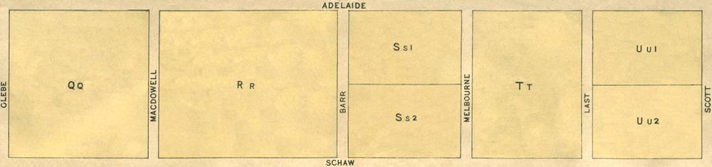
[Qq] Schaw Street - 17a 0r 32p
Bounded on the North by twelve chains and sixty-four links easterly along Adelaide Street from its angle with Glebe Street; on the East by thirteen chains and sixty-one links southerly along McDowall Street; on the South by twelve chains and sixty-four links westerly along Schaw Street to Glebe Street aforesaid; and thence on the West by thirteen chains and sixty-one links northerly along that street to the point of commencement - 17 acres, 32 perches.
Conveyed: 11 Aug 1854, James Lord purchased Crown Land for £51 11s (CT: "Sale of Crown Lands," 11 Aug 1854, https://trove.nla.gov.au/newspaper/article/8776918)
Land Grant: 7 Nov 1854, William Horne, in consideration of £51 11s (RD1: William Horne, p38/1855, https://libraries.tas.gov.au/Digital/RD1-1-30/RD1-1-30P38JPG)
Land Grant: 5 Jan 1855, William Horne, enrolled upon payment of £51 11s (RD1: William Horne, p38/1855, https://libraries.tas.gov.au/Digital/RD1-1-30/RD1-1-30P38JPG)
Land: 18 May 1858, William Horne (owner), 39a 1r 31p, annual rateable value £20; includes [Ss2], [Uu2], [Vv] (TGG: "Valuation Roll," 1858, p696-697, https://www.familysearch.org/ark:/61903/3:1:3QS7-L98F-VZVR)
Land: 19 Nov 1861, William Horne (owner), 39a 1r 31p, annual rateable value £26; includes [Ss2], [Uu2], [Vv] (TGG: "Valuation Roll," 1861, p1694-1695, https://www.familysearch.org/ark:/61903/3:1:3QS7-898F-J93K-Z)
Land: 15 Nov 1864, William Horne (owner), cultivated ground, 39a 1r 31p, annual rateable value £26; includes [Ss2], [Uu2], [Vv] (TGG: "Valuation Roll," 1864, p2076-2077, https://www.familysearch.org/ark:/61903/3:1:3QS7-898F-V3K4)
Land: 26 Feb 1867, William Horne (owner), 39a 1r 31p, annual rateable value £26; includes [Ss2], [Uu2], [Vv] (TGG: "Valuation Roll," 1867, p466-467, https://www.familysearch.org/ark:/61903/3:1:3QS7-898F-V3LK)
Land: 1 Mar 1870, William Horne (owner), 39a 1r 31p, annual rateable value £26; includes [Ss2], [Uu2], [Vv] (TGG: "Valuation Roll," 1870, p356-357, https://www.familysearch.org/ark:/61903/3:1:3QS7-L98F-VB3M)
Advertisement: 21 Nov 1874, "For Sale Cheap" (MERC: "For Sale Cheap," 21 Nov 1874, https://trove.nla.gov.au/newspaper/article/8933598)
Land: 19 Mar 1878, William Horne (owner), 39a 1r 31p, annual rateable value £24 14s; includes [Ss2], [Uu2], [Vv] (TGG: "Valuation Roll," 1878, p494-495, https://www.familysearch.org/ark:/61903/3:1:3QS7-898F-J97X-7)
Property Transfer: bef 8 Aug 1878, William Horne Snr to William Horne Jnr (LIST: William Horne Jnr, title historic, vol 24, fol 22)
Certificate of Title: 8 Aug 1878, registered to William Horne Jnr, merchant clerk, Lyttleton, New Zealand (LIST: William Horne Jnr, title historic, vol 24, fol 22)
Land: 16 Feb 1886, William Horne (owner), 31 acres, annual rateable value £21; includes [Ss2], [Uu2], [Vv] (TGG: "Valuation Roll," 1886, p430-431, https://www.familysearch.org/ark:/61903/3:1:3QS7-998F-2XV)
Conveyed: 25 Nov 1890, William Horne Jnr to James Williams for £300; includes [M-N], [Ss2], [Uu2], [Vv] (LIST: William Horne Jnr, title historic, vol 24, fol 22)
Certificate of Title: 22 Dec 1890, registered to James Williams, farmer (LIST: James Williams, title historic, vol 76, fol 137)
Land: 19 Feb 1895, Mrs W Stonehouse (occupier), James Williams (owner), 39a 1r 31p, annual rateable value £23; includes [Qq], [Ss2], [Vv] (TGG: "Valuation Roll," 1895, p530-531, https://www.familysearch.org/ark:/61903/3:1:3QS7-898F-J1JL)
Land: 28 Mar 1899, Thomas Pulford (occupier), James Williams (owner), 39a 1r 31p, capital value £400, annual rateable value £23; includes [Ss2], [Uu2], [Vv] (TGG: "Valuation Roll," 1899, p326-327, https://www.familysearch.org/ark:/61903/3:1:3QS7-998F-V4YV)
[Rr] Schaw Street - 22a 0r 7p
Bounded on the North by sixteen chains and twenty links easterly along Adelaide Street from its angle with McDowall Street; on the East by thirteen chains and sixty-one links southerly along Barr Street; on the South by sixteen chains and twenty links westerly along Schaw Street; and on the West by thirteen chains and sixty-one links northerly along that street to the point of commencement - 22 acres, 7 perches. (1)
Conveyed: 10 Aug 1854, Edward Bowden purchased Crown Land for £66 11s (CT: "Sale of Crown Lands," 11 Aug 1854, https://trove.nla.gov.au/newspaper/article/8776918)
Land Grant: 7 Nov 1854, Edward Bowden, in consideration of £66 11s (RD1: Edward Bowden, p12/1854, https://libraries.tas.gov.au/Digital/RD1-1-30/RD1-1-30P12JPG)
Land Grant: 12 Dec 1854, Edward Bowden, enrolled upon payment of £66 11s (RD1: Edward Bowden, p12/1854, https://libraries.tas.gov.au/Digital/RD1-1-30/RD1-1-30P12JPG)
Land: 18 May 1858, Edward Bowden Snr (owner), grass paddocks, 57 acres, annual rateable value £15; includes [Nn], [Ww] (TGG: "Valuation Roll," 1858, p696-697, https://www.familysearch.org/ark:/61903/3:1:3QS7-L98F-VZVR)
Property Transfer: aft 21 Sep 1858, estate of Edward Bowden Snr to his widow, Diana (Ayres) Bowden (LIST: Edward Bowden, historic deed, no 11/0831)
Land: 6 Dec 1859, Mrs Diana Bowden (owner, inserted), grass paddocks, 57 acres, annual rateable value £15; includes [Nn], [Ww] (TGG: "Valuation Roll," 1859, p1556-1557, https://www.familysearch.org/ark:/61903/3:1:3QS7-L98F-JT43)
Land: 19 Nov 1861, John White & Simon Arnett (occupiers), Mrs Diana Bowden (owner), grass paddocks, 47 acres, annual rateable value £15; includes [Nn] Bowden (owner), grass paddocks, 47 acres, annual rateable value £12 7s 6d; includes [Nn] (TGG: "Valuation Roll," 1860, p1884-1885, https://www.familysearch.org/ark:/61903/3:1:3QS7-L98F-VQYQ)
Land: 15 Nov 1864, John White & Simon Arnett (occupiers), Mrs Diana Bowden (owner), grass paddocks, 47 acres, annual rateable value £15; includes [Nn] Bowden (owner), grass paddocks, 47 acres, annual rateable value £15; includes [Nn] (TGG: "Valuation Roll," 1864, p2078-2079, https://www.familysearch.org/ark:/61903/3:1:3QSQ-G98F-V3JQ)
Property Transfer: aft 28 Nov 1866, estate of Diana (Ayres) Bowden to her daughter, Eliza (Bowden) Warren (LIST: Edward Bowden, historic deed, no 11/0831)
Land: 26 Feb 1867, John White & Simon Arnett (occupiers), Mrs Eliza Warren (owner), pastoral land, 47 acres, annual rateable value £15; includes [Nn] (TGG: "Valuation Roll," 1867, p470-471, https://www.familysearch.org/ark:/61903/3:1:3QSQ-G98F-VQ9C)
Land: 28 Mar 1899, Edward Swindells (occupier), Mrs Eliza Warren (owner), paddock, capital value £150, annual rateable value £7 (TGG: "Valuation Roll," 1899, p326-327, https://www.familysearch.org/ark:/61903/3:1:3QS7-998F-V4YV)
[Ss1] Adelaide Street - 7a 0r 0p
Bounded on the East by six chains and eighty links southerly along Melbourne Street from its angle with Adelaide Street; on the South by ten chains and thirty links westerly along Lot 2; on the West by six chains and sixty links northerly along Barr Street to Adelaide Street aforesaid; and thence on the North by ten chains and thirty links easterly along that street to the point of commencement - 7 acres. (1)
Land Grant: 28 Dec 1854, Captain William Langdon, in consideration of £30 (RD1: William Langdon, p67/1855, https://libraries.tas.gov.au/Digital/RD1-1-30/RD1-1-30P67JPG)
Land Grant: 16 Jan 1855, Captain William Langdon, enrolled upon payment of £30 (RD1: William Langdon, p67/1855, https://libraries.tas.gov.au/Digital/RD1-1-30/RD1-1-30P67JPG)
Land: 15 Nov 1864, William Langdon (owner), allotments, 12 acres, annual rateable value £3; includes [Aa2] (TGG: "Valuation Roll," 1864, p2076-2077, https://www.familysearch.org/ark:/61903/3:1:3QS7-898F-V3K4)
Land: 26 Feb 1867, William Langdon (owner), allotments, 12 acres, annual rateable value £3; includes [Aa2] (TGG: "Valuation Roll," 1867, p468-469, https://www.familysearch.org/ark:/61903/3:1:3QS7-L98F-V3G3)
Land: 11 Feb 1868, William Langdon (owner), allotments, 12 acres, annual rateable value £3; includes [Aa2] (TGG: "Valuation Roll," 1868, p224-225, https://www.familysearch.org/ark:/61903/3:1:3QS7-898F-JT5Z)
Land: 7 Feb 1871, William Langdon (owner), allotments, 12 acres, annual rateable value £3; includes [Aa2] (TGG: "Valuation Roll," 1871, p186-187, https://www.familysearch.org/ark:/61903/3:1:3QS7-L98F-KSSD)
Land: 19 Mar 1878, William Langdon (owner), allotments, 12 acres, annual rateable value £2; includes [Aa2] (TGG: "Valuation Roll," 1878, p494-495, https://www.familysearch.org/ark:/61903/3:1:3QS7-898F-J97X-7)
Property Transfer: 14 Jul 1879, estate of Captain William Langdon to his son, William Langdon (PROB: William Langdon, No 2225/1879, https://libraries.tas.gov.au/Digital/AD960-1-13-2225)
Land: 28 Mar 1899, Unoccupied, William Langdon (owner), land, 12 acres, capital value £50, annual rateable value £2; includes [Aa2] (TGG: "Valuation Roll," 1899, p326-327, https://www.familysearch.org/ark:/61903/3:1:3QS7-998F-V4YV)
[Ss2] Schaw Street - 7a 0r 2p
Bounded on the East by six chains and eighty-one links northerly along Melbourne Street from its angle with Schaw Street; on the North by ten chains and thirty links westerly along Lot 1; on the West by six chains and eighty-one links southerly along Barr Street; thence on the South by ten chains and thirty links easterly along that street to the point of commencement - 7 acres, 2 perches. (1)
Land Grant: 28 Dec 1854, William Horne, in consideration of £21 1s (RD1: William Horne, p69/1854, https://libraries.tas.gov.au/Digital/RD1-1-30/RD1-1-30P69JPG)
Land Grant: 16 Jan 1855, William Horne, enrolled upon payment of £21 1s (RD1: William Horne, p69/1854, https://libraries.tas.gov.au/Digital/RD1-1-30/RD1-1-30P69JPG)
Land: 18 May 1858, William Horne (owner), 39a 1r 31p, annual rateable value £20; includes [Qq], [Uu2], [Vv] (TGG: "Valuation Roll," 1858, p696-697, https://www.familysearch.org/ark:/61903/3:1:3QS7-L98F-VZVR)
Land: 19 Nov 1861, William Horne (owner), cultivated land, 39a 1r 31p, annual rateable value £26; includes [Qq], [Uu2], [Vv] (TGG: "Valuation Roll," 1861, p1694-1695, https://www.familysearch.org/ark:/61903/3:1:3QS7-898F-J93K-Z)
Land: 15 Nov 1864, William Horne (owner), cultivated land, 39a 1r 31p, annual rateable value £26; includes [Qq], [Uu2], [Vv] (TGG: "Valuation Roll," 1864, p2076-2077, https://www.familysearch.org/ark:/61903/3:1:3QS7-898F-V3K4)
Land: 26 Feb 1867, William Horne (owner), 39a 1r 31p, annual rateable value £26; includes [Qq], [Uu2], [Vv] (TGG: "Valuation Roll," 1867, p466-467, https://www.familysearch.org/ark:/61903/3:1:3QS7-898F-V3LK)
Land: 1 Mar 1870, William Horne (owner), 39a 1r 31p, annual rateable value £26; includes [Qq], [Uu2], [Vv] (TGG: "Valuation Roll," 1870, p356-357, https://www.familysearch.org/ark:/61903/3:1:3QS7-L98F-VB3M)
Advertisement: 21 Nov 1874, "For Sale Cheap" (MERC: "For Sale Cheap," 21 Nov 1874, https://trove.nla.gov.au/newspaper/article/8933598)
Land: 19 Mar 1878, William Horne (owner), 39a 1r 31p, annual rateable value £24 14s; includes [Qq], [Uu2], [Vv] (TGG: "Valuation Roll," 1878, p494-495, https://www.familysearch.org/ark:/61903/3:1:3QS7-898F-J97X-7)
Property Transfer: bef 8 Aug 1878, William Horne Snr to William Horne Jnr (LIST: William Horne Jnr, title historic, vol 24, fol 22)
Certificate of Title: 8 Aug 1878, registered to William Horne Jnr, merchant clerk, Lyttleton, New Zealand (LIST: William Horne Jnr, title historic, vol 24, fol 22)
Land: 16 Feb 1886, William Horne (owner), 31 acres, annual rateable value £21; includes [Uu2], [Qq] (TGG: "Valuation Roll," 1886, p430-431, https://www.familysearch.org/ark:/61903/3:1:3QS7-998F-2XV)
Conveyed: 25 Nov 1890, William Horne Jnr to James Williams for £300; includes [M-N], [Qq], [Uu2], [Vv] (LIST: William Horne Jnr, title historic, vol 24, fol 22)
Certificate of Title: 22 Dec 1890, registered to James Williams, farmer (LIST: James Williams, title historic, vol 76, fol 137)
Land: 19 Feb 1895, Mrs W Stonehouse (occupier), James Williams (owner), house, farm, 39a 1r 31p, annual rateable value £23 - includes [Qq], [Uu2], [Vv] (TGG: "Valuation Roll," 1895, p530-531, https://www.familysearch.org/ark:/61903/3:1:3QS7-898F-J1JL)
Land: 28 Mar 1899, Thomas Pulford (occupier), James Williams (owner), farm, 39a 1r 31p, capital value £400, annual rateable value £23; includes [Qq], [Uu2], [Vv] (TGG: "Valuation Roll," 1899, p326-327, https://www.familysearch.org/ark:/61903/3:1:3QS7-998F-V4YV)
[Tt] Adelaide Street - 13a 2r 17p
Bounded on the North by ten chains easterly along Adelaide Street from its angle with Melbourne Street; on the East by thirteen chains and sixty-one links southerly along Last Street; on the South by ten chains westerly along Schaw Street to Melbourne Street aforesaid; and thence on the West by thirteen chains and sixty-one links northerly along that street to the point of commencement - 13 acres, 2 roods, 17 perches. (1)
Article: 12 Aug 1854, "Crown Land Sales" Section Tt, Lot 1: 6a 3r 8p, Upset Price £20 8s, no bid; Lot 2: 6a 3r 9p, Upset Price £20 8s, no bid (CT: "Sale of Crown Lands," 11 Aug 1854, https://trove.nla.gov.au/newspaper/article/8776918)
Land Grant: 28 Dec 1854, Edward Andrews, in consideration of £40 16s (RD1: Edward Andrews, p154/1855, https://libraries.tas.gov.au/Digital/RD1-1-30/RD1-1-30P154JPG)
Land Grant: 19 Apr 1855, Edward Andrews, enrolled upon payment of £40 16s (RD1: Edward Andrews, p154/1855, https://libraries.tas.gov.au/Digital/RD1-1-30/RD1-1-30P154JPG)
Land: 18 May 1858, Edward Andrews (owner), 54 acres, annual rateable value £80; includes [35], [A1], [Gg1], [Zz] (TGG: "Valuation Roll," 1858, p696-697, https://www.familysearch.org/ark:/61903/3:1:3QS7-L98F-VZVR)
Land: 19 Nov 1861, Edward Andrews (owner), 54 acres, annual rateable value £80; includes [35], [A1], [Gg1], [Zz] (TGG: "Valuation Roll," 1861, p1693, https://www.familysearch.org/ark:/61903/3:1:3QSQ-G98F-J9Q6-B)
Land: 26 Feb 1867, Edward Andrews (owner), 15 acres, annual rateable value £7 10s (TGG: "Valuation Roll," 1867, p465, https://www.familysearch.org/ark:/61903/3:1:3QS7-998F-VS6C)
Land: 1 Mar 1870, Edward Andrews (owner), pastoral land, 35a 1r 29p, annual rateable value £15; includes [A1], [Gg1], [Zz] (TGG: "Valuation Roll," 1870, p355, https://www.familysearch.org/ark:/61903/3:1:3QS7-L98F-VBWF)
Property Transfer: 1 Mar 1871, estate of Edward Andrews to his widow, Catherine (Curtin) Andrews & his son, Charles Edward Andrews (PROB: Edward Andrews, no 613/1871, https://libraries.tas.gov.au/Digital/AD961-1-4-613)
Advertisement: 31 Jan 1879, "For Sale" Well grassed piece of land (MERC: "Properties in Bothwell," 31 Jan 1879, https://trove.nla.gov.au/newspaper/article/8973242)
Advertisement: 12 Mar 1891, "Valuable Property" Lot 1 (MERC: "Valuable Property," 12 Mar 1891, https://trove.nla.gov.au/newspaper/article/12714879)
Conveyed: 20 Sep 1894, Charles Edward Andrews to Charles Manser for £40 (LIST: Charles Edward Andrews, historic deed, no 09/2611)
Land: 2 Aug 1898, Charles Manser (owner, inserted), capital value £30, annual rateable value £1 (TGG: "Valuation Roll," 1898, p1398, https://www.familysearch.org/ark:/61903/3:1:3QS7-998F-K5MG)
Residence: 28 Mar 1899, Charles Manser (owner, occupier), cottage, capital value £150, annual rateable value £8 (TGG: "Valuation Roll," 1899, p326-327, https://www.familysearch.org/ark:/61903/3:1:3QS7-998F-V4YV)
[Uu1] Scott Street- 6a 3r 8p
Bounded on the North by ten chains westerly along Adelaide Street from its angle with Scott Street; on the West by six chains and eighty links southerly along Last Street; on the South by ten chains easterly along Lot 2 to Scott Street aforesaid; and thence on the East by six chains and eighty links northerly along that street to the point of commencement - 6 acres, 3 roods, 8 perches. (1)
Conveyed: 10 Aug 1854, John Allen purchased Crown Land for £20 8s (CT: "Sale of Crown Lands," 11 Aug 1854, https://trove.nla.gov.au/newspaper/article/8776918)
Land Grant: 7 Nov 1854, John Allen, in consideration of £20 8s (RD1: John Allen, p2/1854, https://libraries.tas.gov.au/Digital/RD1-1-30/RD1-1-30P2JPG)
Land Grant: 4 Dec 1854, John Allen, enrolled upon payment of £20 8s (RD1: John Allen, p2/1854, https://libraries.tas.gov.au/Digital/RD1-1-30/RD1-1-30P2JPG)
Land: 28 Mar 1899, Unoccupied, Trustees of John Allen (owners), capital value £12, annual rateable value £1 (TGG: "Valuation Roll," 1899, p326-327, https://www.familysearch.org/ark:/61903/3:1:3QS7-998F-V4YV)
[Uu2] Schaw Street - 6a 3r 9p
Bounded on the East by six chains and eighty-one links northerly along Scott Street from its angle with Schaw Street; on the North by ten chains westerly along Lot 1 purchased from the Crown by John Allen; on the West by six chains and eighty-one links southerly along Last Street aforesaid; and thence on the South by ten chains easterly along that street to the point of commencement - 6 acres, 3 roods, 9 perches. (1)
Land Grant: 4 Jan 1855, William Horne, in consideration of £28 (RD1: William Horne, p78/1855, https://libraries.tas.gov.au/Digital/RD1-1-30/RD1-1-30P78JPG)
Land Grant: 19 Jan 1855, William Horne, enrolled upon payment of £28 (RD1: William Horne, p78/1855, https://libraries.tas.gov.au/Digital/RD1-1-30/RD1-1-30P78JPG)
Residence: 15 Nov 1864, William Horne (owner, occupier), house, barn, cultivated land, 39a 1r 31p, annual rateable value £26; includes [Qq], [Ss2], [Vv] (TGG: "Valuation Roll, 1864, p2076-2077, https://www.familysearch.org/ark:/61903/3:1:3QS7-898F-V3K4)
Residence: 26 Feb 1867, William Horne owner, house, out-buildings, 39a 1r 31p, annual rateable value £26; includes [Qq], [Ss2], [Vv] (TGG: "Valuation Roll," 1867, p466-467, https://www.familysearch.org/ark:/61903/3:1:3QS7-898F-V3LK)
Residence: 1 Mar 1870, William Horne owner, house, out-buildings, 39a 1r 31p, annual rateable value £26; includes [Qq], [Ss2], [Vv] (TGG: "Valuation Roll," 1870, p356-357, https://www.familysearch.org/ark:/61903/3:1:3QS7-L98F-VB3M)
Property Transfer: bef 8 Aug 1878, [Uu2] Schaw St, Bothwell, TAS; William Horne Snr to William Horne Jnr (LIST: William Horne Jnr, title historic, vol 24, fol 22)
Certificate of Title: 8 Aug 1878, registered to William Horne Jnr, merchant clerk, Lyttleton, New Zealand (LIST: William Horne Jnr, title historic, vol 24, fol 22)
Conveyed: 25 Nov 1890, William Horne Jnr to James Williams for £300; includes [M-N], [Qq], [Ss2], [Vv] (LIST: William Horne Jnr, title historic, vol 24, fol 22)
Certificate of Title: 22 Dec 1890, registered to James Williams, farmer (LIST: James Williams, title historic, vol 76, fol 137)
Residence: 19 Feb 1895, Mrs W Stonehouse (occupier), James Williams (owner), house, farm, 39a 1r 31p, annual rateable value £23; includes [Qq], [Ss2], [Vv] (TGG: "Valuation Roll," 1895, p530-531, https://www.familysearch.org/ark:/61903/3:1:3QS7-898F-J1JL)
Residence: 28 Mar 1899, Thomas Pulford (occupier), James Williams (owner), house, farm, 39a 1r 31p, capital value £400, annual rateable value £23; includes [Qq], [Ss2], [Vv] (TGG: "Valuation Roll," 1899, p326-327, https://www.familysearch.org/ark:/61903/3:1:3QS7-998F-V4YV)
Article: 20 May 1899, "The New Assessments" (MERC: "The New Assessments," 20 May 1899, https://trove.nla.gov.au/newspaper/article/9448459)
Residence: 2 Aug 1910, James Williams (owner, occupier), house, 17 acres, capital value £230, annual rateable value £14; includes [Vv] (TGG: "Valuation Roll," 1910, p826-827, https://www.familysearch.org/ark:/61903/3:1:3QSQ-G98N-SSHF)
Electoral Roll: 1914, James Williams, retired; Catherine Williams, domestic duties (ELEC: p16-17/1914, https://www.ancestry.com.au/imageviewer/collections/1207/images/RDAUS1901_100678__0007-00779)
Residence: 3 Nov 1914, James Williams (owner, occupier), house, 17 acres, annual rateable value £14; includes [Vv] (TGG: "Valuation Roll," 1914, p2008-2009, https://www.familysearch.org/ark:/61903/3:1:3QS7-L98N-977Y)
Electoral Roll: 1919, James Williams, retired; Catherine Williams, domestic duties (ELEC: p12-13/1919, https://www.ancestry.com.au/imageviewer/collections/1207/images/RDAUS1901_100682__0007-00825)
Residence: 4 Mar 1919, James Williams (owner, occupier), house, 17 acres, annual rateable value £14; includes [Vv] (TGG: "Valuation Roll," 1919, p492-493, https://www.familysearch.org/ark:/61903/3:1:3QS7-898N-SQ1F)
Bibliography of Sources
CT - TROVE: Colonial Times (Hobart, TAS : 1828-1857). Images. National Library of Australia. https://trove.nla.gov.au : 2023.
ELEC - ancestry: Australia, Electoral Rolls, 1903-1980. Images. Australian Electoral Commission, [Electoral Roll]. https://www.ancestry.com.au/search/collections/1207 : 2023.
LIST - Tasmania: The List: Properties & Titles. Historic Deeds, Grants & Titles. Images. Land Information System Tasmania. Tasmanian Government. Australia. https://www.thelist.tas.gov.au : 2023.
MERC - TROVE: The Mercury (Hobart, TAS : 1860-1954). Images. National Library of Australia. https://trove.nla.gov.au : 2023.
PROB - Libraries Tasmania: Copies of Wills Recording Granting of Probate, 1825-1989 (AD960). Images. Probate Registry (TA1574). Tasmanian Government, Australia. https://www.libraries.tas.gov.au/tasmanian-archives : 2023.
RD1 - Libraries Tasmania: Deeds of Land Grants 1832-1935 (RD1). Images. Registry of Deeds (TA84). Tasmanian Government, Australia. https://libraries.tas.gov.au/tasmanian-archives : 2023.
TGG - FamilySearch: Australia, Tasmania, Government Gazette, 1833-1925. Images. Tasmanian Archive and Heritage Office, Hobart. https://www.familysearch.org/search/collection/2170647 : 2023.