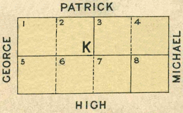
Map 1 - Section K
The information in these reports provides a timeline of occurrences for each property up to 1919, including details such as conveyances and occupancy. Compiled from records at the Tasmanian Archives, the Land Titles Office, Hobart Town Gazette Valuation Rolls, and newspaper articles, this is a work in progress and will be continually updated.
All map sections below have been modified from the Tasmanian Archives: Map - Bothwell B37, AF819/1/26
View original map on the Tasmanian Archives website https://libraries.tas.gov.au/Digital/AF819-1-26
[K1-K2] Patrick Street - 1a 0r 28p
Bounded on the North by four chains and eighty-two links easterly along Patrick Street from its angle with George Street; on the East by two chains and forty-four links southerly along Lot 3; on the South by four chains and eighty-two links westerly along Lots 6 and 5 to George Street aforesaid; and thence on the West by two chains and forty-four links northerly along that street to the point of commencement - 1 acre, 28 perches.
Conveyed: 10 Aug 1854, John Merry Jnr purchased Crown Land for £18 16s (CT: "Sale of Crown Lands," 11 Aug 1854, https://trove.nla.gov.au/newspaper/article/8776918)
Land Grant: 24 Nov 1854, John Merry Jnr, in consideration of £18 16s (RD1: John Merry, p106/1855, https://libraries.tas.gov.au/Digital/RD1-1-30/RD1-1-30P106JPG)
Land Grant: 17 Feb 1855, John Merry Jnr, enrolled upon payment of £18 16s (RD1: John Merry, p106/1855, https://libraries.tas.gov.au/Digital/RD1-1-30/RD1-1-30P106JPG)
Land: 18 May 1858, John Merry Jnr (owner), allotment, annual rateable value £2 (TGG: "Valuation Roll," 1858, p698-699, https://www.familysearch.org/ark:/61903/3:1:3QS7-898F-VZZ3)
Land: 20 Nov 1860, William Maskell (occupier), John Merry Jnr (owner), grass paddock, annual rateable value £2 (TGG: "Valuation Roll," 1860, p1882-1883, https://www.familysearch.org/ark:/61903/3:1:3QS7-L98F-VQGX)
Land: 19 Nov 1861, William Maskell (occupier), John Merry Jnr (owner), grass paddock, annual rateable value £2 (TGG: "Valuation Roll," 1861, p1694-1695, https://www.familysearch.org/ark:/61903/3:1:3QS7-898F-J93K-Z)
Conveyed: bef 20 Apr 1866, John Merry Jnr to Thomas Jones; a deed has not been located (LIST: Thomas Jones, title historic, vol 5, fol 181)
Certificate of Title: 20 Apr 1866, registered to Thomas Jones, farmer (LIST: Thomas Jones, title historic, vol 5, fol 181)
Land: 26 Feb 1867, William Maskell (occupier), Thomas Jones (owner), arable land, annual rateable value £1 10s (TGG: "Valuation Roll," 1867, p468-469, https://www.familysearch.org/ark:/61903/3:1:3QS7-L98F-V3G3)
Conveyed: 20 Mar 1869, Thomas Jones to Mary (Allen) White for £50 (LIST: Thomas Jones, title historic, vol 5, fol 181)
Certificate of Title: 21 Apr 1869, registered to Mary (Allen) White (LIST: Mary White, title historic, vol 9, fol 134)
Land: 1 Mar 1870, John White (owner), paddock, annual rateable value 10s (TGG: "Valuation Roll," 1870, p360, https://www.familysearch.org/ark:/61903/3:1:3QS7-998F-V2RN)
Property Transfer: 13 Oct 1898, Estate of Mary (Allen) White to Vernon White (LIST: Mary White, title historic, vol 9, fol 134)
Article: 18 Oct 1898, Vernon White, named under "Applications to be Registered" (MERC: "Applications to be Registered," 21 Oct 1898, https://trove.nla.gov.au/newspaper/article/9433220)
Certificate of Title: 25 Nov 1898, registered to Vernon White, pastoralist (LIST: Vernon White, title historic, vol 109, fol 38)
Land: 28 Mar 1899, Leo White (occupier), Vernon White (owner), paddock, capital value £100, annual rateable value £5 (TGG: "Valuation Roll," 1899, p328-329, https://www.familysearch.org/ark:/61903/3:1:3QS7-L98F-VDMC)
Land: 2 Aug 1910, Leo White (occupier), Vernon White (owner), paddock, capital value £15, annual rateable value £2 (TGG: "Valuation Roll," 1910, p826-827, https://www.familysearch.org/ark:/61903/3:1:3QSQ-G98N-SSHF)
[K3-K4] Patrick Street - 1a 0r 28p
Bounded on the North by four chains and eighty-three links westerly along Patrick Street commencing at the angle of that street with Michael Street; On the West by two chains and forty-four links southerly along Lot 2 purchased by John Merry the Younger; on the South by four chains and eighty-three links easterly along Lots 7 and 8 purchased by John Colbeck and Washington McMinn respectively to Michael Street aforesaid; and thence on the East by two chains and forty-four links northerly along that street to the point of commencement - 1 acre, 28 perches.
Conveyed: 10 Aug 1854, Charles William Lewis purchased Crown Land for £18 16s (CT: "Sale of Crown Lands," 11 Aug 1854, https://trove.nla.gov.au/newspaper/article/8776918)
Land: 14 Jan 1890, Charles William Lewis (owner), land, 2 acres, annual rateable value 10s; includes [L1-L2] (TGG: "Valuation Roll," 1890, p174-175, https://www.familysearch.org/ark:/61903/3:1:3QS7-L98F-VD5K)
Land: 26 May 1891, An Inquisition of Escheat was recorded for the property belonging to Charles William Lewis, who had reportedly died without heirs many years ago in the Colony of Victoria (LIST: Charles William Lewis, historic deed, no 08/6314)
Land: 4 Aug 1891, Charles William Lewis was recorded as living at Trawool in Victoria when, on this date, he was visiting Tasmania to convey the property [Bb1-Bb2] Adelaide St. (LIST: Gifford White, historic deed, no 08/8630)
Land Grant: 11 Nov 1891, Charles William Lewis, gentleman (LIST: Charles William Lewis, land grant historic, vol 62, fol 145)
Land: 28 Mar 1899, Unoccupied, Charles William Lewis (owner), 2 acres, capital value £50; includes [L1-L2] (TGG: "Valuation Roll," 1899, p328-329, https://www.familysearch.org/ark:/61903/3:1:3QS7-L98F-VDMC)
Land: 10 Nov 1899, The Estate of Charles William Lewis became vested in the Curator of Intestate Estates in Pursuance of an order of the Supreme Court. (LIST: Charles William Lewis, land grant historic, vol 62, fol 145)
Advertisement: 17 Mar 1900, "Property in Township of Bothwell" (MERC: "Property in Township of Bothwell," 17 Mar 1900, p6, https://trove.nla.gov.au/newspaper/article/12785330)
Conveyed: 2 Jun 1900, Executors of Charles William Lewis to Beatrice Edith (North) White (LIST: Beatrice Edith White, title historic, vol 116, fol 39)
Certificate of Title: 12 Jun 1900, registered to Beatrice Edith (North) White (LIST: Beatrice Edith White, title historic, vol 116, fol 39)
[K5-K7] High Street - 1a 3r 2p
Bounded on the South by seven chains and twenty-three links easterly along High Street from its angle with George Street; on the East by two chains and forty-four links northerly along Lot 8; on the North by seven chains and twenty-three links westerly along Lots 3, 2 and 1 to George Street aforesaid; and thence on the West by two chains and forty-four links southerly along that Street to the point of commencement - 1 acre, 3 roods, 2 perches. (1)
Conveyed: 10 Aug 1854, John Morris Colbeck purchased Crown Land for £35 16s (CT: "Sale of Crown Lands," 11 Aug 1854, https://trove.nla.gov.au/newspaper/article/8776918)
Land Grant: 4 Oct 1854, John Morris Colbeck, in consideration of £35 16s (RD1: John Colbeck, p150/1854, https://libraries.tas.gov.au/Digital/RD1-1-30/RD1-1-30P150JPG)
Land Grant: 17 Apr 1855, John Morris Colbeck, enrolled upon payment of £35 16s (RD1: John Colbeck, p150/1854, https://libraries.tas.gov.au/Digital/RD1-1-30/RD1-1-30P150JPG)
Land: 18 May 1858, John Morris Colbeck (owner), 3½ acres, annual rateable value £5; includes [J1], [J3-J5] (TGG: "Valuation Roll," 1858, p696-697, https://www.familysearch.org/ark:/61903/3:1:3QS7-L98F-VZVR)
Land: 19 Nov 1861, John Morris Colbeck (owner), 3½ acres, annual rateable value £5; includes [J1], [J3-J5] (TGG: "Valuation Roll," 1861, p1694-1695, https://www.familysearch.org/ark:/61903/3:1:3QS7-898F-J93K-Z)
Land: 15 Nov 1864, John Morris Colbeck (owner), 3½ acres, annual rateable value £5; includes [J1], [J3-J5] (TGG: "Valuation Roll," 1864, p2076-2077, https://www.familysearch.org/ark:/61903/3:1:3QS7-898F-V3K4)
Land: 26 Feb 1867, John Morris Colbeck (owner), 3½ acres, annual rateable value £5; includes [J1], [J3-J5] (TGG: "Valuation Roll," 1867, p466-467, https://www.familysearch.org/ark:/61903/3:1:3QS7-898F-V3LK)
Land: 1 Mar 1870, John Morris Colbeck (owner), 3½ acres, annual rateable value £5; includes [J1], [J3-J5] (TGG: "Valuation Roll," 1870, p356-357, https://www.familysearch.org/ark:/61903/3:1:3QS7-L98F-VB3M)
Land: 7 Feb 1871, John Morris Colbeck (owner), 3½ acres, annual rateable value £2 10s; includes [J1], [J3-J5] (TGG: "Valuation Roll," 1871, p186-187, https://www.familysearch.org/ark:/61903/3:1:3QS7-L98F-KSSD)
Advertisement: 30 Apr 1874, "Allotments at Bothwell" (MERC: "Allotments at Bothwell," 30 Apr 1874, https://trove.nla.gov.au/newspaper/article/8929643)
Advertisement: 16 Mar 1878, "Bothwell Stock Sale" 3 allotments (MERC: "Bothwell Stock Sale," 16 Mar 1878, https://trove.nla.gov.au/newspaper/article/8961100)
Conveyed: bef 25 Feb 1879, John Morris Colbeck to Charles Hart; a conveyance was never executed (LIST: Charles Hart, title historic, vol 26, fol 90)
Land: 25 Feb 1879, Charles Hart (owner), annual rateable value £1 (TGG: "Valuation Roll," 1879, p372-373, https://www.familysearch.org/ark:/61903/3:1:3QS7-998N-9SKG)
Certificate of Title: 2 Jul 1879, registered to Charles Hart, hawker (LIST: Charles Hart, title historic, vol 26, fol 90)
Land: 20 Feb 1883, Henry Craig (occupier), Charles Hart (owner), annual rateable value £1 (TGG: "Valuation Roll," 1883, p386-387, https://www.familysearch.org/ark:/61903/3:1:3QS7-898N-9QDD)
Conveyed: 17 Dec 1885, Charles Hart to Samuel Craig (LIST: Charles Hart, title historic, vol 26, fol 90)
Certificate of Title: 23 Jan 1886, registered to Samuel Craig, labourer (LIST: Samuel Craig, title historic, vol 50, fol 81)
Land: 14 Jan 1890, Samuel Craig (owner), annual rateable value £1 (TGG: "Valuation Roll," 1890, p174-175, https://www.familysearch.org/ark:/61903/3:1:3QS7-L98F-VD5K)
Land: 28 Mar 1899, Samuel Craig (owner), annual rateable value £2 (TGG: "Valuation Roll," 1899, p328-329, https://www.familysearch.org/ark:/61903/3:1:3QS7-L98F-VDMC)
Conveyed: 20 Jun 1912, Samuel Craig to Luke Evans for £55 (LIST: Samuel Craig, title historic, vol 50, fol 81)
Certificate of Title: 28 Jun 1912, registered to Luke Evans, butcher (LIST: Luke Evans, title historic, vol 203, fol 80)
[K8] High Street - 0a 2r 14½p
Bounded on the East by two chains and forty-four links northerly along Michael Street from its angle with High Street; on the North by two chains and forty-two links westerly along Lot 4; on the West by two chains and forty-four links southerly along Lot 7 to High Street aforesaid; and thence on the South by two chains and forty-two links easterly along that street to the point of commencement - 2 roods, 14½ perches. (1)
Conveyed: 10 Aug 1854, Washington McMinn purchased crown land for £14; surname listed as Levien (CT: "Sale of Crown Lands," 11 Aug 1854, https://trove.nla.gov.au/newspaper/article/8776918)
Conveyed: 12 Jul 1862, Washington McMinn to Claude Midwood for £14 (LIST: Washington McMinn, historic deed, no 05/1173)
Property Transfer: 20 Jan 1865, Estate of Claude Wade Midwood to his brother, Vernon Midwood (LIST: Claude Wade Midwood, historic deed, no 09/2126)
Property Transfer: 18 Nov 1891, Estate of Vernon Midwood to his son, Claude Wade Midwood (LIST: Claude Wade Midwood, historic deed, no 09/2126)
Conveyed: 21 Jul 1894, Claude Wade Midwood to Robert Edward Blake for £15 (LIST: Claude Wade Midwood, historic deed, no 09/2126)
Land: 28 Mar 1899, Robert Edward Blake (owner), allotment, capital value £15, annual rateable value £1 (TGG: "Valuation Roll," 1899, p324-325, https://www.familysearch.org/ark:/61903/3:1:3QSQ-G98F-V8FR)
Land: 3 Nov 1914, Robert Edward Blake (owner), allotment, annual rateable value £1 (TGG: "Valuation Roll," 1914, p2008-2009, https://www.familysearch.org/ark:/61903/3:1:3QS7-L98N-977Y)
Land: 4 Mar 1919, Robert Edward Blake (owner), allotment, annual rateable value £1 (TGG: "Valuation Roll," 1919, p492-493, https://www.familysearch.org/ark:/61903/3:1:3QS7-898N-SQ1F)
Bibliography of Sources
CT - TROVE: Colonial Times (Hobart, TAS : 1828-1857). Images. National Library of Australia. https://trove.nla.gov.au : 2023.
LIST - Tasmania: The List: Properties & Titles. Historic Deeds, Grants & Titles. Images. Land Information System Tasmania. Tasmanian Government. Australia. https://www.thelist.tas.gov.au : 2023.
MERC - TROVE: The Mercury (Hobart, TAS : 1860-1954). Images. National Library of Australia. https://trove.nla.gov.au : 2023.
RD1 - Libraries Tasmania: Deeds of Land Grants 1832-1935 (RD1). Images. Registry of Deeds (TA84). Tasmanian Government, Australia. https://libraries.tas.gov.au/tasmanian-archives : 2023.
TGG - FamilySearch: Australia, Tasmania, Government Gazette, 1833-1925. Images. Tasmanian Archive and Heritage Office, Hobart. https://www.familysearch.org/search/collection/2170647 : 2023.